Left-Hand Menu
Tools for navigation, drawing shape files, accessing custom lists, waypoints, and more
Tools Menu
Use the Tools menu to navigate the map.

| Select Click to select individual objects on the map. Click and drag to select multiple objects. |
Find Nearest Click to find map objects nearest to a specified location. |
| Pan Click and drag to pan the map. |
Get Directions Click to get directions and show the route on the map. |
| Measure Click to open the Measure menu and measure area, distance or view the current coordinates. |
Road Map Click to create a road map. |
| Zoom In Click to use the Zoom In tool. |
Print Coordinates Click to view and print coordinates from a point on the map. |
| Zoom Out Click to use the Zoom Out tool. |
Location Select Click to select map objects by location. |
| Zoom To Click to zoom to an address or map objects. |
Risk Analysis Click to generate a Pipeline Risk Analysis. |
Tip:
Select the Pan tool, hold Shift and click and drag a box on the map to zoom to the area selected.
Connectivity Menu
Use the Connectivity menu to add and manage nodes and links.

NodeClick to add, edit, or delete nodes. |
LinkClick to add, edit, or delete links. |
Objects Menu
Use the Objects menu to add supplementary objects to the map.

WaypointClick to add a waypoint. |
Water WellClick to add a water well. |
Waypoint SignClick to add a waypoint sign. |
LabelClick to add your own label to the map. |
Custom Lists Menu
Use the Custom Lists menu to add selected objects to your custom lists.
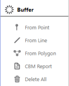
Pipeline ListClick to add selected Pipeline(s) to a custom Pipleline List |
Facility ListClick to add the selected Facility(ies) to a custom Facility list. |
Well ListClick to add the selected Well(s) to a custom Well List. |
Buffer Menu
Use the Buffer tools to find and select objects within a certain distance of an object, pipeline, or point on the map.

From PointClick to find and select all objects within |
CBM ReportClick to create a well CBM report from |
From LineClick to find and select all objects within |
Delete AllClick to delete all Buffers from the current map. |
From PolygonClick to find and select all objects within |
Tip:
Once you've made a selection using the From Point, From Line, or From Polygon tool, refer to Select Report to view or export object data.
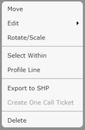
Right click a Buffer to modify it, select the objects within the Buffer (Select Within), or view the Profile Line of the Buffer:
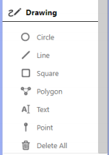
Drawing Menu
Use the Drawing tools to add visual data to the map. A pop-up box is displayed when a Drawing tool is selected where you can modify the color or thickness, and select which labels are displayed on the map.

CircleClick to draw a circle (from the center-point outwards). |
PolygonClick to draw irregular shapes (double click to end and close the shape). |
LineClick to draw a line (single click to continue line in another direction, double click for end point). |
TextClick to add a label to the map. |
SquareClick to draw a square (from the top-left hand corner). |
Delete AllClick to delete all drawings from the current map. |
Tip:
Hold Ctrl while using a Drawing tool to snap to an object on the map.
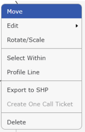
Right click a drawing or a label on the map to modify it, select the objects within a drawing (Select Within), or view the Profile Line of a drawing:

Tip:
After you have added drawings or labels to a map, you will likely want to save, share, or print it. Refer to Save, Share and Export Maps